Scrutinizing the LIC Rezoning Draft Zoning Proposal
CB2 Land Use Committee weighs ambitious growth plans against community needs for affordability, green spaces, and infrastructure
In this week’s meeting of Queens Community Board 2’s Land Use Committee (of which I’m vice chair), City Planning representatives presented an extensive and detailed overview of proposed zoning changes for Long Island City.
The overall zoning framework is multifaceted, designed to address various urban planning goals. The study area encompasses regions adjacent to Queens West, Hunters Point South, Queens Plaza, Court Square, and Dutch Kills, aiming to create a cohesive development plan for this rapidly evolving section of Queens. It primarily aims to promote housing development with Mandatory Inclusionary Housing (MIH) requirements, aiming for a mix of market-rate and affordable units. The plan also encourages the creation of mixed-use environments, including residential, commercial, and light industrial uses to maintain the area's diverse economic base. It also aims to create open space opportunities, particularly along the waterfront, to enhance public access and improve quality of life for residents. Additionally, the framework seeks to strengthen the economic vitality of light industrial districts, recognizing the importance of maintaining a robust and diverse job market within the neighborhood.
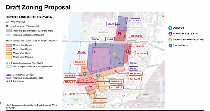
Draft zoning proposal
The plan divides the study area into four distinct sub-districts, each with tailored zoning proposals:
1. Waterfront (Sub-district 1): This area is crucial to the plan, focusing on creating a vibrant, accessible waterfront. The proposal introduces M1-5A/R8 and M1-6A/R9 zones. The M1-5A/R8 zone allows for a residential floor area ratio (FAR) of 7.2 and a community facility, commercial, and manufacturing FAR of 6.5. It has a base height of 105 feet, with a transition height of 215 feet along the Waterfront Special District. The M1-6A/R9 zone is more intensive, permitting a residential FAR of 8, a community facility FAR of 10, and commercial and manufacturing FAR of 8. Its base height is set at 135 feet, with a transition height of 285 feet. Both zones' maximum heights are governed by the sky exposure plane (a zoning concept that defines an imaginary sloping plane extending upward and outward from a specified height above the street, which building structures must not penetrate), allowing for flexible building designs that maximize views and light.
2. North and Court Square Core (Sub-district 2): This area sees the most intensive development potential. The M1-6A/R10 zone allows for a residential FAR of 12, community facility FAR of 10, and commercial and manufacturing FAR of 8. The M1-6/R9 and M1-6/R10 zones introduce varied FARs for different uses, with a consistent base height of 150 feet. The sky exposure plane concept is employed here to govern building heights above the base, allowing for architectural solutions that can potentially result in very tall structures.
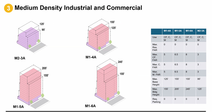
3. Industrial and Commercial Area (Sub-district 3): This area maintains a focus on job-creating uses while allowing for increased density. The M1-4A zone permits an FAR of 5 across all uses, with a maximum base height of 125 feet and a maximum building height of 155 feet. The M1-5A zone increases this to an FAR of 6.5, a base height of 155 feet, and a maximum height of 205 feet. The M1-6A zone further intensifies development with an FAR of 8, keeping the base height at 155 feet but allowing a maximum height of 245 feet. In contrast, the M2-3A zone is less intensive, with an FAR of 3, a base height of 96 feet, and a maximum height of 125 feet.
4. Core and South Area (Sub-district 4): This area proposes a gradient of densities, transitioning from lower-density residential areas to more intensive mixed-use zones. It includes designations from M1-2A/R6A to M1-5A/R8, each with specific FAR and height limitations tailored to their location and proximity to transit. For instance, the M1-2A/R6A has a residential FAR of 3.9 and other uses at FAR 3, with a base height of 65 feet and max height of 95 feet. This transitions up to M1-5A/R8, which allows a residential FAR of 7.2 and other uses at 6.5, with heights governed by the sky exposure plane.
The plan also incorporates several special considerations. The Waterfront Access Plan (WAP) is being updated to ensure cohesive development of the waterfront areas. City-owned sites, particularly along the waterfront, are given flexibility in zoning to allow for future public uses or potential public-private partnerships. A loop road is also proposed along the waterfront to enhance accessibility and create a continuous public promenade. The loop road is designed to connect 5th Street with 44th Avenue at Vernon Boulevard. It aims to provide legible (easily understood and navigated) and connected public access along the waterfront, featuring two-way vehicular traffic, bike accommodations (either dedicated or shared), and 15-foot sidewalks on both sides. While some details are still being finalized, the road is intended to create new frontage between open space and waterfront development.
Community concerns
The Land Use Committee raised a number of concerns to City Planning at the meeting:
Open/green space: We expressed concerns about the lack of guaranteed public open/green space in the plans. We emphasized the critical importance of such spaces for community well-being, mental health, and quality of life, especially in light of lessons learned during the COVID-19 pandemic. We highlighted the current deficit of green spaces in the district and stressed that the high-density development proposed would exacerbate this issue. We questioned why the plans didn't include specific designations for new parks or green areas, particularly away from the waterfront. We urged City Planning to consider incorporating more substantial and guaranteed green spaces into the plan. They said that the plan would also consider the integration of Privately Owned Public Spaces (POPS) as a tool to increase public open space within private developments, which could result in additional plazas, pocket parks, or other accessible areas throughout the district.
Affordability: We raised questions about affordability requirements and the number of affordable housing units that would be created. MIH, a cornerstone of the residential development strategy, requires 20-30% of units to be affordable (depending on the option chosen by developers), which ensures a significant contribution to the city's affordable housing stock. We sought clarity on the specifics of the MIH requirements, including the percentage of affordable units required and the income levels they would serve. We asked about the potential for deeper affordability or a higher percentage of affordable units beyond the standard MIH requirements, given the high desirability and rapid development of Long Island City. Our discussions touched on the possibility of incorporating additional affordability tools, such as the use of housing vouchers or other subsidy programs, to ensure a wider range of income levels could be served.
Infrastructure improvements: We requested more specifics on infrastructure improvements and community benefits that would come with the rezoning. We emphasized the critical need for substantial upgrades to support the increased density and population growth anticipated under the new zoning. We asked about specific plans for sewer and water main improvements, noting existing issues with the aging infrastructure through Long Island City (including in Blissville). We also sought information on transportation enhancements, including potential subway station upgrades, bus route expansions, and bicycle infrastructure improvements. We asked about school capacity, with requests for details on planned new schools or expansions to accommodate the influx of new residents. We stressed the importance of having these commitments clearly outlined and tied to the rezoning approval process, rather than vague promises for future consideration. We requested a comprehensive list of planned improvements, their estimated costs, funding sources, and implementation timelines. We also urged for a mechanism to ensure these community benefits would be delivered in tandem with new development, rather than lagging behind. Overall, we made it clear that our support for the rezoning would be heavily influenced by the concrete commitments made to infrastructure and community benefits.
Environmental Impact Statement (EIS): We discussed the process for reviewing and providing input on the plans, including the upcoming EIS. We expressed concern about the timeline for the EIS release and the limited 60-day period we would have to review and respond to this complex document. We plan to form a working group within our committee to focus specifically on reviewing the EIS when it becomes available. We emphasized our commitment to providing substantive feedback on the EIS and urged City Planning to view us as partners in ensuring a comprehensive and accurate assessment of the rezoning's potential impacts on our community.


I’m curious about what the plain M-16A zone will allow. Is residential allowed?